This upland region of New England is often referred to as the New England Plateau or the Northern Plateau. There are peaks over 1,000 metres (3,300 feet) high, with the highest point being 1,585 metres (5,200 feet) above sea level. Other major peaks include Point Lookout
The New England Highlands are located in the heart of the country, with the towns of Tenterfield, Glen Innes, Guyra, Inverell, Armidale and Walcha being the administrative centres. The two main cities of Tamworth and Armidale are the New England Highlands.
New England has been one of the earliest established inland areas of the Australian Federation. Many English people have long been dissatisfied with Sydney's rule, so everyone hopes to establish a "New England" in the northern region. In the 1930s and 1960s, the New England New State Movement advocated the separation of New England from New South Wales. The movement was closely associated with the National Party, which could have formed the government of such a new country. On 29 April 1967, a referendum was held in the region to establish a new state from northern New South Wales with a vote of 54% in favour. Chapter VI of the Australian Constitution allows for the creation of new states, subject to the consent of the relevant state parliament. But the New South Wales Parliament never agreed to the separation of New England.
The New England Highway is an 878 km long highway in Australia, stretching from Hexham in Newcastle, New South Wales, southwards to Yarraman, at the northern end of Toowoomba in Queensland. Back then, it took 13 hours to drive from Sydney to the Gold Coast, but now it only takes 9 hours after the opening of the new Highway 1.
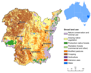
Located 410km from Sydney, New England is the westernmost region of New South Wales; from the canyons and rushing rivers of the mountains to the fertile agricultural plains in the west; from the heat of summer to the chill of winter at the top of the mountain ranges; from the region's rich Aboriginal history to its hazy past, it is the land of the Bashland people. It is a fossil lover's paradise with many precious and semi-precious stones nearby. There is excellent fishing in the region's dams, rivers and streams, and the state's most famous national parks and World Heritage areas are located in the New England region. It also includes the country music capital, cotton capital, koala capital, hot spring capital, sapphire capital, pecan capital, Scottish cultural city, and the highest city in Australia...
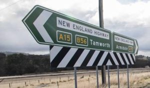
leavePort Macquarie,I suggest Along the B56 Oxley HighwayEnterThe inland mountain area is about 3 hours’ drive away. First visitNew EnglandUniversity town Armidale, After staying one night, continue to Guyra and the Scottish cultural city of Glen Innes. Arrive at Inverell in the evening and stay at the Sapphire City. Stay at Moree Hot Springs before the afternoon of the next day. You can visit pecan orchards along the way. Enjoy the natural hot springs in Moree (stay for two nights), Then the cotton capital Narrabri, the koala capital Gunnedah, Finally, we arrived at Tamworth, the capital of country music, and took the triangular route.
1.New EnglandUniversity Town: Armidale Armidale

Armidale is located in New England in the northeast of New South Wales, a plateau city with an average altitude of 1,000 meters (the highest city in Australia).
It is located on the railway line 274 kilometers north of Newcastle and 477 kilometers from Sydney. It was established in 1885 and has a population of 26,000, which is considered a large city in Australia.
Nearby are livestock producing high-quality Merino wool, orchards, wood industry areas, and cultural centers. Armidale has developed education, agriculture and retail industries, and its economy is mainly based on animal husbandry, orchards and timber production, producing high-quality Merino wool. At the same time, emerging digital fields are important employment growth points.
Armidale is one of the first communities in Australia to enjoy ultra-fast fiber-optic broadband. The city has rich educational resources and is an important educational and cultural center. The famous University of New England is located here. The city also has other educational institutions such as vocational and further education colleges, public schools and private schools.
Prior to British settlement of New South Wales, the Aboriginal Aniwen people occupied the area that is now Armidale. English pastoralists first entered the area in the early 1830s, following early exploration of the area by John Oxley. Oxley suggested the area for grazing, and soon squatters established a number of leases in the area.
Armidale was originally founded in 1839 by George James MacDonald, Commissioner of Crown Lands and Commander of the New England Border Police. MacDonald established his barracks at this site and named it after Armadale on the Scottish Isle of Skye, the ancestral homeland of the MacDonald family.
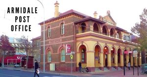
On 1 April 1843, the heritage-listed Armidale Post Office, designed by James Barnett, opened. The town was surveyed in 1848 and gazetted in 1849 with the intention of providing a market and administration for farms, but the gold rush soon followed after gold was discovered in the nearby Rocky River and Gala Gap, rapidly expanding the town in the 1850s.
The gold mining settlement of Hillgrove, about 40 kilometres east of Armidale, was the site of Australia's first hydroelectric scheme. Gara River hydroelectric power was started here and the remains of these schemes can still be seen on the Gara River below the Blue Hole at Fort Doyle. The nearby town of Uralla contains the grave of famous outlaw Fred Ward, Captain Thunder, who caused trouble in the area in the 1860s. Like Ned Kelly, locals embraced him as a larrikin hero and took full advantage of him as a tourist attraction. Armidale became a town in 1863 and was proclaimed a city in 1885.

Armidale is a cathedral city and the seat of both the Anglican and Roman Catholic bishops. St Peter's Anglican Cathedral replaced the original St Peter's Church and was designed by Canadian architect John Horbury Hunt, who also designed the Borromeominba at the University of New England. St. Peter's Basilica opened for worship in 1875, and the tower was added in 1938. The Catholic Cathedral of Saints Mary and Saint Joseph was dedicated on December 12, 1919. The city center is laid out in a grid of streets. The main street was known as Beard Street, named after two founding settlers who had beards. The courthouse was built in the 1850s and remains a prominent feature of the central district. The city walking tour is arranged free of charge every day by the local municipal government.

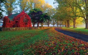
Hosted by Armidale every March: The Wool Fashion Awards showcases fashion designers using Merino wool. The Mid-Autumn Festival is a popular annual event in Armidale in April. The festival features a street parade, stalls and celebrations throughout the city. It is a popular attraction in the city, often promoting Armidale's diverse culture (for example, posters set up by the council attempt to attract tourists with the slogan "Armidale Food Tour") and autumn colours. During May, the annual New England Wool Fair takes place, featuring wool fashions, crafts, demonstrations, wool shearing contests, yard dog trials and demonstrations, wool bale rolling contests, and more.
The next episode takes you to visit tourist attractions near Armidale.