In this episode, we will take another route from Tamworth along Thunderbolts Way B56 back to Forster on Coastline Highway 1. The driving time is about 4 hours (255 kilometers of mountain roads). On the way, we will pass through the famous Barrington Tops National Park. The park is located on a 25-kilometer plateau between extinct volcanoes and lush valleys. It is famous for its wilderness listed as a World Heritage Site and is also a famous gold mine in history.

The first stop on this route is to visit the historic town of Walcha, which was built in 1852 and has many Australian national historical architectural heritage sites. (Note; Register of the National EstateThe National Heritage Register was a heritage register listing Australia's natural and cultural heritage sites but was closed in 2007. From 2003, the National Heritage Register of Australia and the Commonwealth Heritage Register were created, and by 2007 the registers were replaced by these and the various state and territory heritage registers. Listed places remain non-statutory archives and can still be accessed through the National Heritage Database.)
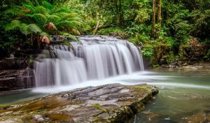
Along with the nearby Apsley Gorge and Falls, Apsley Falls are two waterfalls on the Apsley River in the Northern Tablelands. The falls are located approximately 20 km east of Wlacha and 1 km off the Oxley Highway in a deep gorge, which is part of the Oxley Wild Rivers National Park. This is the most striking and scenic waterfall. The first waterfall has a drop of about 65 meters, and the second waterfall has a drop of about 800 meters, 58 meters straight down to the bottom of the canyon, which is very spectacular.
Continue driving for two hours to reach Barrington Tops, a protected national park located approximately 200 kilometres north of Sydney, covering an area of 76,512 hectares between Scone, Singleton, Dungog, Gloucester and East Gresford. The park forms part of the Gondwana Rainforests World Heritage Site and was inscribed on the National Heritage List of Australia in 2007.
In 1969, the area between Barrington Tops, Mount Royal and Gloucester Top was declared Barrington Tops National Park. In 1986 it was listed as a World Heritage Site and subsequently as a wilderness area. Some of the rivers that flow through the Barrington Ranges are classified as wild rivers, meaning they are very pure and unpolluted. The highest peak is Brumlow Top, 1586 meters above sea level. It is under the jurisdiction of the Hunter Valley Council.
Another local attraction is Aussie Ark, a non-profit organization dedicated to saving Australian wildlife from extinction. Visitors can enjoy a "devil's tour" in the wildlife sanctuary, see wild animals in their natural environment, and stay in the hideout of the Tasmanian devil. You can also enjoy the beautiful Barrington Tops Mountains in the surrounding area.
Eighth stop: FosterForster
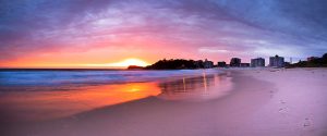
Forster-Tuncurry is located on the east coast of New South Wales, approximately 300 kilometres from Sydney. It is a popular holiday resort for Sydney residents, with a permanent population of over 20,000.

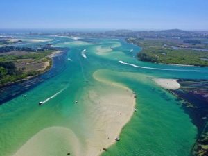
Forster and Tuncurry are two twin towns connected together, located at the mouth of the Coolongolook River and bounded by the Coolongolook River. Forster is located on the south bank and Tuncurry is located on the north bank. The two towns are connected by a 600-meter-long bridge.
Forster-Tuncurry is an important holiday destination on the east coast of New South Wales. It has beautiful natural scenery, large lakes and white sandy beaches. The most popular beaches are Forster Main Beach and Nine Mile Beach. Wallis Lake is rich in delicious oysters. Other popular attractions include the Bicentennial Trail, Cape Hawke lookout and Booti Booti National Park. There are fishing and outdoor activities suitable for the whole family nearby, including dolphin watching by boat, Big Buzz Fun Park, National Motorcycle Museum, mini-karting, etc.
Foster was named after William Foster, the second Premier of New South Wales who later returned to London to take up other government posts. On October 1, 1872, Foster's first post office opened, with John Willie Breckenridge as postmaster with an annual salary of £10. In addition, he adopted the local name "Tuncurry" from the Worimi Aboriginal people for the town next door, which may mean "a lot of fish".
The area was home to the Worimi Aboriginal people for tens of thousands of years before the arrival of Europeans.
Captain Cook sailed along the coast and passed through the area on May 12, 1770. In 1818, John Oxley and his party, on their way to Sydney after an inland expedition, sailed from Booti Booti to Boomerang Beach for an overnight stay. Oxley named a local lake "Wallis Lake" after the commander of the Newcastle Penalty.
The area was part of a million acres of land granted to the Australian Agricultural Company (AAC) in 1825. They found the land barren, and the grant was returned to the king. By the 1850s, the Australian Agricultural Company employed Chinese shepherds to fish along the coast, drying their catch before selling it in Sydney, the goldfields and overseas.
The Godwin family purchased land at Hawke's Point in 1863. They arrived here from Gosford in 1856. George Garrick Godwin sent wild honey and Cape Hawke's oysters to Sydney. One of his daughters was the first white person born in the area. The first vehicle ferry from Forster to Tuncurry began operating in 1922. In 1959, a bridge across Wallis Lake connected the two towns. Transportation has become more convenient.