Big Axe
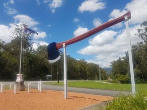
The Big Axe is located about 2 km north of Kendall in Kew, 33 km from Port Macquarie, adjacent to the Kew Visitor Information Center and is about 8 meters high. The first sculpture was originally built in 1979 and had to be rebuilt in 2002 due to termite damage. The axe was built to commemorate the local logging industry and Mannie McCarthy, the champion of the Sydney Farmers' Show logging competition, who broke the world record with a time of 52.5 seconds in 1928. The new axe was built with local donations and volunteer Peter Harper.
Lake Cathie Big Bowl, the world's largest lawn bowling

The Great Lawn Bowls is located 16 kilometres from Port Macquarie near Lake Casey. Lake Casey is a small town with a permanent population of only about 2,000 people. The town is a popular holiday destination because of its lakes, lagoons and beaches.
The big blue lawn bowling ball was built just outside the Lake Casey Bowling Club. The men's bowling club was founded on December 10, 1970, and the women's bowling club was founded on January 22, 1971. The first Lake Casi Lawn Bowling Competition was held on February 10, 1974. It is now the 46th. In order to promote lawn bowling activities and commemorate this glorious day, the blue large lawn bowling ball was launched in November 1975.
The large lawn bowling ball was built by Stan Kanaar in a workshop below his home. This giant lawn bowling ball, said to be the largest in the world, has a diameter of 1.907 mm (6 ft 2 in) and weighs 2 tonnes. The outer surface consists of 100mm thick cement (about 32 bags) applied on a framework of 75mm water pipes and 13mm steel bars. The entire steel frame is wrapped with two layers of 13mm steel mesh.
Big Oyster

The Big Oyster is located in Taree, 80 kilometres from Port Macquarie. Once a popular restaurant and souvenir shop, The Big Oyster in Taree, New South Wales is now a car dealership. The Big Oyster is right on the Pacific Highway. It is about 12 feet tall and 30 feet wide, with plenty of space inside for visitors to view it. It was founded in 1990 by Hungarian immigrants, brothers Louis and Attia Mokany, who also founded Big Prawn and Big Sheep.
The local Manning River produces more than 4 million famous oysters every year, accounting for 30% of the total production in New South Wales. The Great Lake Oyster Festival is held every September.
The name Taree is even thought to come from Tareebit, an Aboriginal name for a local fig tree. The indigenous people used the fruit to supplement their diet, which was mainly seafood and fish from the rivers. Taree was established as a private town in 1854 by Henry Flett, son-in-law of William Wynter, who originally settled in the area in 1831. Today, Taree is home to approximately 20,000 people. Taree is the centre of an important agricultural region, located over 300 kilometres north of Sydney. It can be reached via the Pacific Highway or by train via the North Shore Railway.
Stop 8: New England Regional
New England regional towns include:Tenterfield,Inverell,Glen Innes, Moree, Armidale, Narrabri,Tamworth, Gunnedah, Quirindi and Wee Waa There are 10 major towns, each with its own characteristics, suitable for visiting all year round.
Australia's Aboriginal people have lived in the region for tens of thousands of years, with the Kamilaroi people being the main inhabitants in the west. The population of the Highlands during colonial times is estimated to be between 1,100 and 1,200 people, which is considerably lower than the Liverpool Plains and Gwyde River areas, estimated at between 4,500 and 5,500. Conflict, disease, and environmental damage reduced the highland population to as few as 400 people by the 1890s. The first European to explore the New England region was the English explorer John Oxley, who travelled through the southern New England range near Apsley Falls before discovering and naming Port Macquarie in 1818. Hamilton Collins Sempill was the first settler in New England who ran the Wolka Run in 1832 and built a slate house near what is now Langford, New England. In the 1830s, more squatters moved their flocks to the northern tablelands as they were replaced by Australian Agricultural Companies, which took over resources in the Hunter Valley.
Work began in 1838 using convicts to build a road, then called the Major's Line, through the Great Dividing Fields, linking the wool-growing settlement of Wacha with Port Macquarie. The road was later named Oxley Highway. On May 22, 1839, the New England Territory was gazetted: New England Territory: Encircled by a line of compass from the top of Mount Werrigimber, at the source of the Hastings River, northwards; and by a line of compass from the top of Mount Werrigimber westwards. By 1850, all major lines of communication had been built, and the government provided little assistance. According to census data, the population of the New England area, including the hillside, was 143,788 in 1957 and 164,128 in 1971. The New England region had a population of 300,000 at the 2018 census and includes the local government areas of Armidale Dumaresq, Inverell, Walcha, Glen Innes Severn, Gunnedah, Guyra, Gwydir, Liverpool Plains, Moree Plains, Narrabri, Tamworth Regional and Uralla.
~~~~~~~~~~~~~~~~~~~~~~~~~~~~~~~ Follow-up ~~~~~~~~~~~~~~~~~~~~~~~~~~~~~~~~~~~~~~~~~~