leaveForster after, Let's go to the next stopTea Garden Heading to the tea garden.
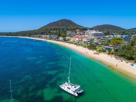
Ninth StationTea Garden tea garden
The tea garden is located 223 kilometers north of Sydney via the Pacific Highway, 76 kilometers northeast of Newcastle, 11 kilometers from the Pacific Highway, and 16 meters above sea level. Population: approximately 3,000.
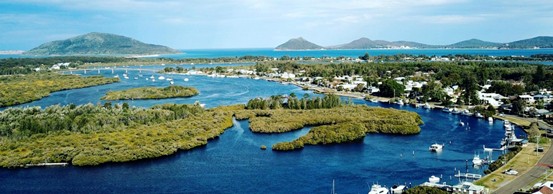
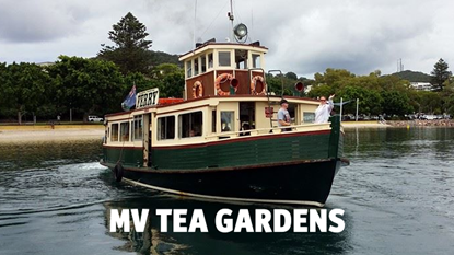
Tea Gardens is a small township adjacent to the northern port of Port Sphinx. Across the waters of Port Stephens, there are regular ferries to and from Nelson Bay every day. It is separated from Hawks Nest by the expanding estuary of the Murr River, which flows out of Lake Murr and into Port Stephens. In 1974, the two sleepy towns were connected by the Singing Bridge, so called because it "sings" like a harp when a strong southwest wind blows. The local economy has historically been based on seafood and timber. Today, tourism and retirement are two major "industries", and people hope that this quiet town away from the Pacific Highway can become a sunny and pleasant place to go. Fishing, surfing, windsurfing and kayaking are popular here.
No one knows exactly where the name Tea Garden came from. This may be because in 1826 an Australian agricultural conglomerate was granted the rights to grow 500,000 acres of tea in the area, but was unsuccessful, although it is equally likely that it got its name from the abundance of tea bushes along the Myall River.
There may be little on the NSW coast that has not been developed in recent years, but the towns of Tea Gardens and Eagles Nest have seen less development than most. They still retain the charm of a 1950s fishing port, which is probably why former Prime Minister John Howard and his family often holidayed here.
Local tourist attractions include; Lions Park Lookout is a good elevated viewing point 2 km northwest of the tea plantation on Tea Plantation Road (Myall Way), where the local Lions Club has built a rest area with parking, picnic and toilet facilities. This is a vantage point with views of the tea plantations and Eagle's Nest, as well as clear views of the two headlands of Port Stephens.
Marine Drive is a great place to take a walk along the banks of the Myall River. It runs along the riverbank and its quiet frontage is the most impressive feature of the tea estate, with a children's park, a swimming pool and pedestrian access to the bridge.
Cycling around Tea Gardens The greatest pleasure for cyclists in this area is that it is very flat and therefore very easy. I provide very useful website which lists 11 cycle routes in total, ranging from a short trip around Eagle's Nest and tea plantations to a 52km journey from Eagle's Nest to Fried Corner Ferry. Visit http://www.teagardensonline.com.au/index_files/CycleBooklet.pdf for a downloadable booklet.
In 1791 the convict ship the Salamander entered the port, and in 1795 deputy surveyor Charles Grimes drew up a chart in which he described the port as low and sandy. In 1801, the Governor ordered a survey of the port by William Patterson.
Governor Macquarie personally inspected the port in 1812 and found it "very good, very safe and very spacious" but thought it had too many shoals and the land was too poor to establish a colony.
The Australian Agricultural Company (AAC) acquired 500,000 acres of land, including tea plantations, in 1826 and established an operation at what is now Carrington with 80 settlers, 720 sheep and some horses and cattle.
It is said that AAC had tried and failed to grow tea and hired Chinese assistants as consultants on tea production. They also acted as gardeners, growing vegetables for company settlements. Hence the name Tea Garden.
By the late 1820s, passing ships and whalers used Port Stephens as a source of timber and water. The approach to the port was dangerous and there were numerous shipwrecks, but after the first lighthouse was built at Stephens Point in 1862, the route became a must for local cargo ships, and a ferry service across the Mill River was launched in 1928. The Singing Bridge was completed and opened to traffic in 1974.
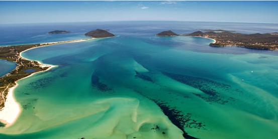
Stop 10: Port Stephens
In May 1770, Captain James Cook, sailing along the east coast of Australia, spotted the port as a possible harbour and named it Port Stephens after his friend Sir Philip Stephens. Sir Philip Stephens is the First Secretary of the Admiralty and a Member of Parliament.
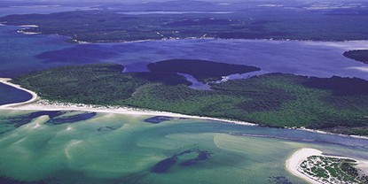
Port Stephens is a large, well-protected natural harbour covering 134 square kilometres and spanning 24 kilometres from the mouth of the Karua River to the headlands of Mount Tomare and Yakaba Point in the Eagle Valley. The coastline of the port is mainly lined with small villages - Tahlee, Bundabah, Hawks Nest, Oyster Cove, Tanilba Bay. Corlette, lemon tree passage and tea garden.
There is continued urban development along the southeastern coastline, stretching from Shoal Bay to Soldiers Point and including the townships of Salamander Bay, Nelson Bay and Port Stephens. The 'port' is characterised by the coves and estuaries of the Myall River, Tilligerry Creek and Karuah River. There are quiet white sand beaches and lush bushland. Historically, much of the land here was owned by the Australian Agricultural Company (AAC), but by the 1950s it had become a popular holiday resort and retirement location for people from Sydney and Newcastle. Its great appeal is that it is undeveloped, therefore affordable and sleepy. Today, with exclusive accommodation options at Corlette and Nelsons Bay, 'The Port' is ideal for recreational activities including game fishing, beach and rock fishing, sailing, dolphin and whale watching cruises, boat and yacht charters, bush walks, horse riding, surfing, water skiing, swimming and parasailing. To be continued in the next episode.