NSW 20
Port Stephens is a popular holiday backyard for Sydney families. According to the 2018 census, more than 29,000 people live within 3 kilometers of the 113-kilometer coastline, and more than 38,000 people live within 10 kilometers. It is a 2.5-hour drive from Sydney.
In 1795, the crew of the Royal Navy Providence discovered a group of fugitives and natives. Worimi
The tribesmen live together. Port Stephens became known as a refuge for fugitives, so in 1820 a garrison was established at what is now known as Soldiers Point. In 1816, the 63-ton clipper ship Lambton, commanded by Captain James Collett, began shipping timber and wool from the port. The suburb of Collette was named after the captain.
Most of the soil in Port Stephens is quite poor, with limited potential for agricultural development. For this reason, no large towns developed there historically, nor did it develop into an important port. The main city and port of Newcastle developed at the mouth of the Hunter river, approximately 45 kilometres southwest of Port Stephens.
In 1920, a proposal was put forward by country newspaper, the Daily Observer, for Port Stephens to become the capital of the new state. The proposal was the brainchild of Observer editor Victor Charles Thompson, in response to ongoing resentment in rural Australia about centralised funding and administration in Sydney, which many rural newspapers claimed neglected aid to rural Australian towns. During World War II, the Royal Australian Navy established HMAS Raid, an amphibious landing training facility in Nelson Bay, due to its remote location and the absence of a large civilian population. The workstation from HMAS is still there and is used by the Port Stephens Community Arts Centre.
Many small towns have developed around the port as fishing, vacation, and retirement communities. Since the 1970s, these towns have expanded significantly as road access from Sydney improved and the coastal retirement lifestyle became increasingly popular. With an increasing number of international tourists, its popularity is comparable to that of the Blue Mountains.
Since the local tourism facilities are well-developed and there are many attractions, I will introduce several important tourist towns here:
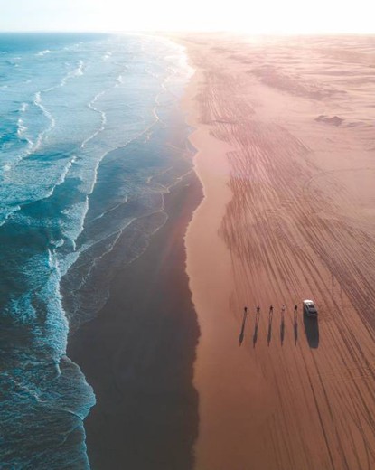
1.Anna Bay Stockton Sand Dunes and BeachAnna Bay Stockton Beach & Sand Dunes
Stockton Beach is a 15-minute drive from Nelson Bay. It is 32 kilometers long and stretches from Stockton to Anna Bay. Stockton Beach has been the site of numerous shipwrecks and plane crashes over the years. During World War II, it was reinforced to withstand a possible attack by the Imperial Japanese Army. During that time, it served as both a bombing and gunnery range, as well as a dumping ground for aircraft to discard unused bombs when returning from training exercises. The length and hard-packed surface of the beach make for many interesting outdoor activities along the beach, making it popular with four-wheel drive (4WD) enthusiasts. Four-wheel drive vehicles are permitted on Stockton Beach with a valid permit. The beach is also popular with fishermen, who can catch several different types of fish. In addition, you can ride horses and camels on the beach. The beach is also rich in pipi clams, but because too many people go to dig them, it affects the landscape of the beach. Now each person can only dig up to 50 per day, and they can only be used as bait and cannot be taken away, otherwise they will be heavily fined.
Stockton Beach, facing the Tasman Sea, begins on the north side of the breakwater at the entrance to Newcastle Harbour, and is the northernmost suburb of Newcastle, extending approximately 32 kilometres in a north-easterly direction to Anna's Bay in Port Stephen. Some areas are up to 1 kilometre wide, while at the end of Stockton are the narrowest without dunes. Each year these dunes move northwards by about 4 metres. The sand on Stockton Beach varies from hard to soft and changes daily with the wind and weather. The largest flowing dunes in the southern hemisphere were formed thousands of years ago and cover an area of 4,200 hectares, 1,800 of which are forested. These truly stunning natural dunes are over 30 metres in height and have slopes of up to 60 degrees, creating a magnificent landscape ideal for sandboarding and an exciting outdoor activity all year round.
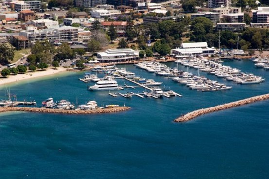
- Nelson Bay
Nelson Bay is a major tourist centre in Port Stephens, ideal for dolphin and whale watching, surfing, diving, fishing and other water recreational activities. The eastern boundary of Nelson Bay is within Tomare National Park, while almost all of the southeast is within the park. Nelson Lighthouse is a lighthouse built in 1875 and located at the northeast corner of the
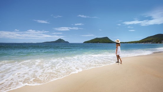
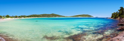
- Shoal Bay
Sandbank Bay was named by Governor Macquarie when he explored the port in 1812. This is a simple description of the sandbars common in the area. It is located on the eastern side of Nelson Bay and has beautiful beaches and is known for its excellent fishing, as well as the famous diving sites in Halifax Park. The main attractions in the area are Mount Tomaree and Tomaree Head, which lies to the east of this small settlement.
- Fingal Beach and Barry ParkFingal Beach and Barry Park
South of Fingal Bay is Barry Park, which has a delightful walking track and boardwalk, developed by the Fingal Bay Parks and Reserves Committee with funding from the Coastal Care Fund. They removed the Marantana and Bidu bushes and restored the original Australian bush. “The track and boardwalk pass through a range of distinctly different plant communities, with smooth-barked apple, coastal sandpiper, giant honeysuckle, broad-leaved paperbark, coastal tea tree, in addition to rushes and reeds in the boardwalk area. “The site also contains many different types of native orchids, such as the green-capped orchid and the brown-capped orchid. This area is the only place in Port Stephens where they have been recorded.
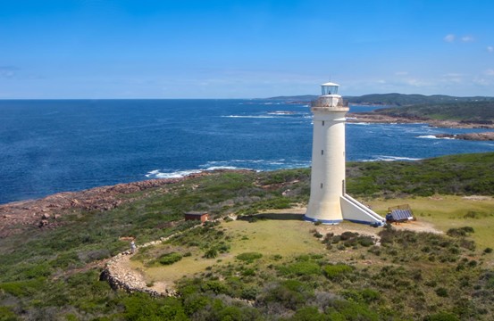
- Cape Stephens and Cape Stephens Lighthouse - Shark IslandPoint Stephens and Point Stephens Lighthouse – Shark Island
The northern end of Fingal Bay beach is known as Fingal Spit, with Point Stephens looming to the east and Shark Island looming. There have been many shipwrecks on the island, so a lighthouse was built in 1862 - consisting of a stone tower and a beacon. It was designed by colonial architect Alexander Dawson and is made of Sydney sandstone. At that time, there was a narrow cape 200 meters wide and 5 meters above sea level connected to the mainland, covered with shrubs. By the end of the 19th century, electric poles appeared. The lighthouse was converted to solar power in 1989 and it still operates today, although without a lighthouse keeper. The light can be seen up to 17 nautical miles out to sea. Its altitude is 38 meters. It was not converted to electrical mains until the 1960s. Prior to this, it was first powered by kerosene and then, in 1922, by pressurized acetylene gas.