After leaving the Hunter Valley wine region, I'd like to share with you the roadside markers around the Central Coast, followed by my favourite Sydney backyard, Brisbane Water, and the Northern Beaches.
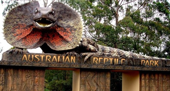
Large Ruffed-necked Umbrella Lizard Big Frill-necked Lizard, Somerby
Drivers travelling north from Sydney on the M1 may notice a lumbering dinosaur on the hill from the highway, but there's another “big animal” at Australia's Reptile Park that may be even more real and impressive. As visitors enter this Central Coast wildlife park, a giant frilled lizard “hisses” at the gate entrance. Although this reptile is not what attracts people to this award-winning tourist attraction, it does make an impression, especially on the large group of children celebrating their birthdays here. This large frilled umbrella lizard is the park's ambassador, standing at 10 metres, and was built on 7 September 1996.
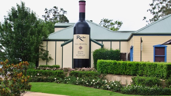
magnum The Big Bottle
The Big Bottle is marked at Pokolbin in the Hunter Valley, at the entrance to the Hunter Valley Garden Village. At 7 metres high and 1,5 metres long, this is Australia's oldest winemaking region and home to some of the best vineyards. Thousands of visitors come every year to taste some of the best wines in the region. Built in 1998, its neck forms a chimney with a bonfire inside. It is also heated in winter.
giant mosquito Big Mosquito, Hexham
The giant insect known as “Ossie the Mossie” was built in 1993 at a cost of A$17,200 and replaced in 2005 and 2010, modelled on the local Hexham Grey mosquito species. Surrounded by swampy marshes and floodplains, Hexham in New South Wales is an ideal habitat for mosquitoes, which breed and lay their eggs in moist conditions. Ochlerotatus alternans (Hexham grey), known for its huge size and ferocity, is common in the area. The mosquito is made of fibreglass and is 3.5 metres long, and is built into the Hexham Bowling Club advertising rack.
Hewham is a suburb of Newcastle, settled in the 1820s and named after the small English market town of Hexham, home to many of the coal miners who grew up in Newcastle-upon-Tyne.

The world's largest sundial(Nikkei) World's Largest Sundial, Singleton
The Singleton Sundial in New South Wales is our sundial for the month. It is the largest sundial in the southern hemisphere. For a period in the 1980s it was also the Guinness World Record holder for the largest sundial in the world. It is 14.6 metres long, 7.92 metres high and the table (the part of the dial on which the shadow is cast) is 12 metres long! The structure weighs a staggering 30 tonnes!
Constructed from the original convict hewn stones from the local Singleton early street building, the sundial supports the structure with 2.5 kilometres of steel reinforcement to prevent any future corrosion damage. The sundial points south, parallel to the earth's axis of rotation.
An ancient timekeeping device set in the middle of modern development, the Singleton sundial symbolises the local community's bicentenary celebrations and provides a gateway to the area around the River Hunt, the picnic and recreation area, and the region's largest sports area.
The Great Sundial was a gift from Lemington Mine to commemorate Australia's bicentenary. It still claims to be the largest monolithic sundial in the southern hemisphere.
Singleton is a small town on the banks of the Hunter River in New South Wales, Australia. Singleton is 197 kilometres north-west of Sydney and 80 kilometres north-west of Newcastle.
Singleton's main urban areas include the city centre, Singleton Heights, Dunolly, Darlington, the Retreat, Wattle ponds and Hunterview. surrounding villages include
Surrounding villages include Broke, Camberwell, Jerrys Plains, Goorangoola/Greenlands and Belford.
Singleton is located in the northeastern part of the geological formation known as the Sydney Basin and borders New England. The town is located at the intersection of the New England Highway and the Putty Road, a golden highway that runs around the town to the south. The town is located at the intersection of the New England Highway and the Putty Road, which runs south around the town, and is served by local and long-distance rail services, with Singleton Train Station located at the southern end of the town centre. The Singleton train station is located at the southern end of the town centre, and there are both intra-city and inter-city bus services.

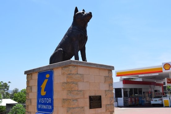
Big Blue Heeler
A statue commemorating the Australian Cattle Dog (Blue and Black), which was bred at “Dartbrook”, about 12 kilometres north of Muswellbrook.
Thomas Hall's “Dartbrook” saw the need for a special dog to help manage cattle, especially in the vast Upper Hunter Valley region, and in 1840, Thomas Hall was able to achieve this through breeding with Blue Merle Drover's from Northumberland and Dingo, an Australian dingo capable of withstanding high temperatures and working quietly over long distances to effectively round up wild bushland cattle. In 1840, Thomas Hall was bred to the Dingo, an Australian dingo capable of withstanding high temperatures, travelling long distances, working quietly, and effectively rounding up cattle in the wild bush.
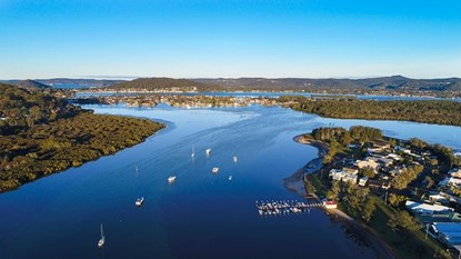
Sydney BackyardBrisbane Water Brisbane, capital of Queensland, Australiabody of water
Brisbane Waters is a wave-dominated weir estuary located in the Central Coast region north of Sydney. The waters originate at the confluence of the Narara and Coorumbine Rivers, south-east of Gosford, and sail south for about 18 kilometres to the mouth of Broken Bay, about 7 kilometres from the Tasman Sea. Many towns and suburbs surround Brisbane Waters, including:
Blackwall, Booker Bay, Davistown, Empire Bay, Erina, Ettalong Beach, Gosford, Green Point, Hardys Bay, Kilcare, Kincumber, Koolewong, Phegans Bay, Point Frederick, Point Clare, Saratoga, Tascott, Wagstaffe, and Woy Woy.
St Hubert's Island in Brisbane WatersSt Huberts Island, Riley IslandRileys Island, and Pelican.;Pelican Island, Brisbane Water National Park to the west and Boody National Park to the east.
For thousands of years, the land around Brisbane Waters has been occupied by the Australian Aboriginal peoples of Darkinjung and Kuringgai, who used the estuary and foreshore areas for their cultural activities.
Brisbane Waters was named in 1825 in honour of Sir Thomas Brisbane, Governor of New South Wales from 1820 to 1825. The area is now Sydneysiders' favourite waterfront residential area.