Continue to Brisbane Water and Northern Beaches.
Brisbane Waters is part of the traditional lands of the Dakin and Klingai Aboriginal peoples. Brisbane Waters is of great significance to the Aboriginal people of the surrounding area as there are many areas listed on Australia's National Estate Register, including the Daleys Point area and Staples Lookout west of Woy Woy. The original colonial explorers of the area were assisted by Bungaree, a Kuringai tribal leader who later helped Philip Parker King and Matthew Flynn. Bungaree was the leader of the Kuringai tribe who later helped Philip Parker King and Matthew Flinders travel around Australia.
European settlement in the twentieth century led to the development of an extensive network of local ferries, including a ferry service to an otherwise isolated orphanage, a commuter service from Gosford to Woy Woy, and a third business dedicated to the transport of agricultural produce. The last ferry service between Boothbane and the waterfront ceased in 1971. The only existing ferry service is to Empire Bay, Davistown, Saratoga and Woy Woy communities, operated by Central Coast Ferries.
In 1973, a development company intended to remove all native vegetation on the island to make way for construction on the island, and local residents demanded a green ban.
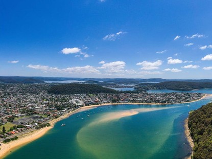
The Brisbane Waters estuary and foreshore have exceptionally high scenic value, including pristine vegetation and extensive waters that can be seen from many locations. Beaches, inlets and bays can be distinguished in the foreground from the inner juxtaposition of bush-covered mountains in the distance. Through the existing major vantage points, the public can experience the Brisbane Estuary and its surrounding landscape, including the Brisbane Waters National Park.
The average riverbed height in Brisbane waters is about 5 metres, usually as low as 3 metres, and Brisbane waters are considered to be the shallowest, with a tidal influence of ±0.4 metres (1 ft 4 in). The bay narrows at a point known as the rift, near Ettalong Beach. The rift has fast tidal currents.
The oyster farming industry is an important part of the local economy. In terms of Sydney Rock oyster production, the Brisbane Estuary produced approximately 450,000 dozen oysters in 2017/2018, with a total value of A$3.3 million, which accounted for approximately 4.6% of the NSW industry's total value in 2017/2018, followed by the only artificial pearl farming industry in all of NSW.
In 2019, more than 110 species of birds were recorded in the estuary; there are 60 species of endangered animals, 14 species of endangered animals, 16 species of endangered plants and 8 species of endangered plants. Approximately 2,277 hectares of Brisbane Water is classified by BirdLife International as an Important Bird Area.
There are a number of scenic walking routes that are popular with hikers, as well as water sports, houseboat accommodation and fishing for the whole family, and I myself prefer to take the local Ferry from one stop to another to savour the residential areas along the waterfront.
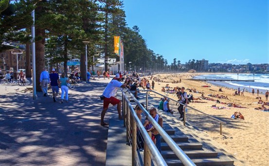
Northern BeachesNorthern Beaches
The Northern Beaches Council is a local government department located in the Northern Beaches region of Sydney, New South Wales. It has close to 100 towns and coastal villages, including Palm Beach, Dee why, New Port, Fresh Water, Mona Vale ......
On 12 May 2016, the Northern Beaches Council was officially amalgamated following the merger of the Manly, Pittwater and Warringah Councils.The Council covers an area of 254 square kilometres and had an estimated population of 252,878 people at the 2016 Census, making it the third most populous local government area in the Sydney region.
The first Mayor of the Northern Beaches Council was Cr. Michael Regan from the local Northern Beaches Independent Team, who was elected on 26 September 2017.At the time of the 2016 Census, the population of the Northern Beaches Local Government Area was; 48.8% of which were male and 51.2% were female. Aboriginal and Torres Strait Islander people accounted for 0.61 TP3T of the population; the NSW and Australian averages were 2.91 TP3T and 2.81 TP3T, respectively.The average age of a Northern Beaches Council member was 42 years; the national average was 38 years.
In the 2016 Census, 68% residents indicated that their ancestors were either Australian or Anglo-Saxon Anglo-SaxonThe national average is 52.11 TP3T. 18.91 TP3T of households speak two or more languages at home; the national average is 22.21 TP3T. 79.81 TP3T of households speak only English at home; the national average is 72.71 TP3T. On the land now known as the North Beach In the land now known as the Northern Beaches, the traditional indigenous people are the Klingui of the Eora Nation. Within a few years of European settlement, the Klingui had largely disappeared from the area, largely due to the smallpox outbreak of 1789. Much evidence of their habitation still exists, notably their petroglyphs in Kuring-gai Chase National Park, which is located in the north-west of the Northern Beaches. The Northern Beaches were explored in the early days of the colony of Sydney, just weeks after the arrival of the first fleet of ships. However, for much of the 19th and early 20th centuries it remained a rural area with only small settlements in the valleys between the headlands. Although geographically close to the city centre, the area is over 100 kilometres by road from Sydney via the Mona Vale Road.
The Manly Municipal Authority was first established on 6 January 1877 as the first local government authority on the northern beaches.On 7 March 1906, Warringah, Warringahshire
Along with 132 other new counties, it was proclaimed by the New South Wales Government Gazette. It runs roughly from Broken Bay in the north to the Manly Lagoon in the south, and from the west via the Middle Harbour and Cowan Rivers. It covers an area of 264 square kilometres and has a population of about 2,800 with 700 houses. From 1951 to 1980, Mackellar Shire Council operated as a joint venture between Manly City Council and Warringah Shire Council as a supplier and retailer of electricity and natural gas on the northern beaches. In the final report of the Royal Commission on Local Government Boundaries in Clancy in 1945-46, it was recommended that Manly and Warringah local councils should be amalgamated to create a local council for the northern beaches, but this was not carried out in the Act passed in 1948.
On 2 May 1992, the Governor of New South Wales proclaimed the creation of the Borough of Pittwater, which roughly followed the Riding of A previously known as Warringah Shire, and on 1 July 1993, with the enactment of the new Local Government Act 1993, the Cities of Manly and Pittwater were rechristened “Manly City Council” and “Pittwater City Council”, and Warringah Shire Council was named “Warringah City Council”. Manly and Pittwater were renamed "Manly City Council" and "Pittwater Water Council" and Warringah County Council was named "Warringah City Council". In the next episode, we'll introduce you to more tourist attractions in our neighbourhood.