Sydney's backyard tourist attractions and landscape introduction (II):
- Australia's oldest national park, Royal National Park
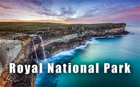
The Royal National Park is located in the southern suburbs of Sydney, the capital of New South Wales, approximately 35 kilometres by car from Sydney's city centre. It covers an area of 150.91 square kilometres and is vast, with several small towns (settlements) within the park itself.
The Royal National Park is located about a 10-minute drive south of the major Sutherland Shire town of Sutherland and is Sydney's renowned historic national park. Established in 1879, it is known locally as ‘Nasho‘ or ’The Royal', and is the second oldest national park in the world (after Yellowstone National Park in the USA) and the oldest national park in Australia. In 2006, it was listed on the Australian National Heritage List.
The Royal National Park was originally named National Park. In 1954, during her visit to Australia, Queen Elizabeth II of the United Kingdom travelled by train and passed through this area. Subsequently, in 1955, it was officially renamed the Royal National Park. In December 2006, the entire Royal National Park was listed on the Australian National Heritage List.
The Royal National Park boasts a unique landscape of ancient ruins, a wide variety of plants, birds and animals, and diverse scenery including rainforests and beaches. It is ideal for hiking, mountain biking, surfing, picnicking, or whale watching.
The Royal National Park contains three residential settlements: Bundeena, Maianbar and Audley, all of which are accessible by well-maintained paved roads; Bundeena and Maianbar face Port Hacking and can also be reached by ferry from Cronulla on the opposite side.
The iconic sites of Wedding Cake Rock, near Bundeena, and Figure 8 Pool, in the park's most southern part, are the Royal National Park's most famous attractions, drawing tens of thousands of visitors each year. Furthermore, the Royal National Park is also the starting point of the Grand Pacific Drive, considered one of Australia's most beautiful road trips. From here, self-drive travellers will occasionally traverse mountains and cross the sea, finally reaching Shoalhaven Heads in the Southern Highlands, accompanied by the deep blue ocean.
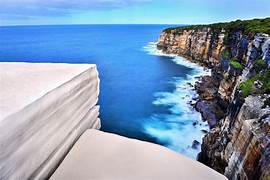
Tofu Stone (Wedding Cake Rock): Tofu Stone is a huge, square, white boulder situated on the edge of a cliff. Its shape and colour strongly resemble a giant white wedding cake, hence its name, Wedding Cake Rock. Tofu Stone is what Chinese people call it. Tofu Stone's location is quite remote, and it cannot be reached directly by car. The closest point accessible by car is the town of Bundeena within the Royal National Park, and then you need to walk for approximately 3 kilometres along the Wedding Cake Rock hiking trail to reach it. The route involves many uphill and downhill mountain paths, and the round trip takes at least 3 hours. Therefore, to return safely before sunset, you must plan your time in advance.
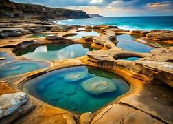
Figure 8 Pools: The Figure 8 Pools get their name from their unique shape, which resembles the Arabic numeral “8”. They are naturally formed in granite on the coast, with the open sea bordering the pools and forming the Figure 8 Pools scenic area alongside a cluster of surrounding pools. The Figure 8 Pools are a completely natural environment, with no cafes or restaurants along the way, so be sure to bring enough snacks and be mindful of wildlife. Most importantly, check the tide times for Burning Palms Beach before planning your trip. You need to visit during low tide, as high water levels will completely submerge the coastal rocks.
The park is located on the traditional lands of the Australian Aboriginal people of the Dharawal. More precisely, the area that today is known as the Royal National Park was the northeastern part of this nation's Aboriginal language group. The Dharawal Nation included the coastline of the ocean and estuaries from Botany Bay to the Shoalhaven River, and forest-covered lands extending as far inland as the Georges River and Appin, and possibly Camden.
This park was once connected to the Eastern Suburbs and Illawarra line by a railway, but this line was closed and converted into a heritage tramway, operated by the Sydney Tramway Museum located in Loftus. Sydney Tramway Museum in Loftus.
The park has many cycle paths, walking trails, barbecue areas and picnic spots. Over 100 kilometres of trails offer a variety of scenery. Cycling is permitted on some designated tracks, and only on specially marked tracks within the park. Cycle paths are two-way; be careful when crossing these trails. There is a $12 AUD fee to enter the park by car.
The most popular walking track is the Coast Track, situated along the park's eastern edge offering unique coastal scenery. This is a 30-kilometre track requiring a walk from Bundeena to Otford, or vice versa. Walkers are advised to allow 2 days. The Wallumarra Track (Wallumarra means education/conservation in Aboriginal language) was built in 1975 to meet the growing need for environmental education and as a supplement to the park's network of walking tracks. The park is extensively used by schools, TAFE, universities and other groups for environmental education.
The park has been burnt by bushfires a number of times, most notably the Black Christmas fires of 1939, 1994 and 2001. Australian native bushland regenerates naturally after bushfires, and by 2008, there were still few signs of these fires. During times of extreme fire danger, the park service may close the park for visitor safety, until bushfires returned in 2019.
Bonnie Vale, North Era and Uloola Falls all have designated camping areas. These are the only places within the park where camping is permitted and they operate on a booking/registration system, requiring campsites to be reserved in advance. The park charges a vehicle entry fee, but walking in is free.
In the Royal National Park, littoral rainforest, which is typically the first vegetation to be destroyed during coastal development, has survived the destruction suffered elsewhere in the 19th and 20th centuries. An example of this vegetation occurs to the south of the Coast Track and is often referred to as the “Palm Jungle” and comprises a typical tuckeroo (Cupaniopsis anacardioides) forest growing beneath a coastal tea-tree (Leptospermum laevigatum) and long-leaved matrush (Lomandra longifolia).
Riparian forests typically occur in an area 10-25 metres from the high-water mark and support a unique plant community that often contains many rare or endangered species found only alongside a few streams worldwide. Common vegetation growing in this area includes Blackbutt ( *Melaleuca pilularis*), Sydney Red Gum (*Angophora costata*), Water Gum (*Tristaniopsis laurina*), Bottlebrush (*Callistemon* spp.), Tea Tree (*Leptospermum* spp.), Woollsia (*Woollsia pungens*), *Epacris* spp., Heath (*Epacricis ericifolia*), Coastal Rosemary (*Westringia undulata*), Pine-leafed Geebung (*Persoonia pinifolia*), Willow-leafed Hakea (*Hakea salicifolia*), Lomandra (*Lomandra* spp.), Cattail (*Typha orientalis* / *Typha domingensis*), Rush (*Juncus* spp.), Reeds and Tree Ferns.
A wide variety of molluscs, crustaceans, insects, fish and birds call this riparian zone home, with a wide variety of life found in the creeks of Royal National Park. The longfin eel (Anguilla), which migrates from marine spawning grounds when juvenile and adult eels mature in the creeks and streams of Royal National Park, can often be seen in the dark depths of pools and ponds along freshwater waterways such as the Hacking River.